


Storm Damage Cleanup Continues in Charles City, North Iowa
Cleanup efforts continue in Charles City and across northeast Iowa following thunderstorms that brought heavy rain and strong winds to the region Tuesday (05.21) night.
Charles City Water & Street Superintendent Cory Spieker says, “Crews continue to work to cleanup after last night’s storms. We will make passes through today and tomorrow to pick up piles of branches and remove trees that were taken down by the storm. We ask all residents to place piles of branches along the curb line in piles.”
Spieker adds, “There are still numerous power lines and power poles down. Please leave all cones and barricades that are blocking streets in place until repairs are made and they are removed by the proper personnel. ”
He also says, “Thank you to all the city department crews, county dispatch and all of the city residents that helped us and their neighbors last night. It’s so great to see the community work together.”
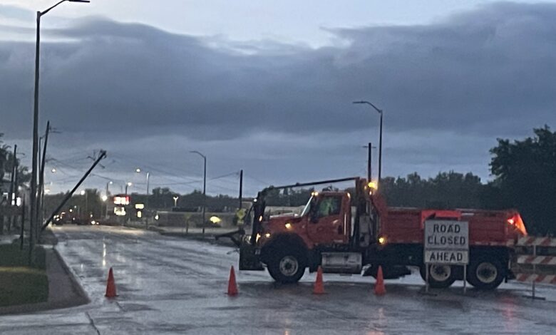
The storm took down power poles and power lines on South Grand Avenue in Charles City resulting in the road being closed for several hours.
The City says Wildwood Golf Course is closed Wednesday (05.22) due to the storms causing downed trees and flooding over parts of the course.
Right now the Cedar River is expected to crest around 12’ on Wednesday evening which is at the low end of minor for flooding. At that point Brackett Street may close but all other streets should be open, but please be mindful and attentive when driving as flash flooding may occur.
Some storm damage reports from the National Weather Service:
Location: Charles City, IA
Description: Tstm Wnd Dmg
Remarks: Trees and power lines down in town.
Location: 2 S Saint Ansgar, IA
Description: Tstm Wnd Dmg
Remarks: Power lines blown over and grain bin destroyed.
Location: Marble Rock, IA
Description: Tstm Wnd Gst
Magnitude: 60 MPH
Remarks: Damage reported in town.
Location: 1 SE Marble Rock, IA
Description: Tstm Wnd Dmg
Remarks: Report from mPING: 1-inch tree limbs broken; Shingles blown off.
Location: 1 WSW Greene, IA
Description: Tstm Wnd Dmg
Remarks: Emergency management reported trees blown onto a house west of Greene near the intersection of 110th St and Keystone Ave. Time estimated with radar.
Location: West Union, IA
Description: Tstm Wnd Dmg
Remarks: Trees and powerlines down, including a tree down on a house. Also trees and powerlines down in Elgin.
Location: 2 SE Aredale, IA
Description: Tstm Wnd Dmg
Remarks: Emergency manager reported damage to farmstead outbuildings near the intersection of Clay Ave and 160th St near Dumont. Damage included an outbuilding being blown over. Time estimated with radar.
Location: Fayette, IA
Description: Tstm Wnd Dmg
Remarks: 50 mph wind gusts knocked down trees near town.