




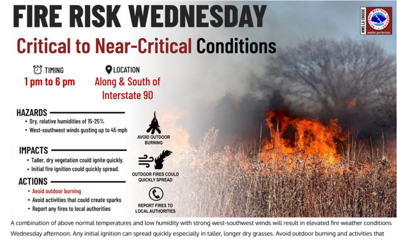
***Pic courtesy of New Hampton Fire Department
URGENT - FIRE WEATHER MESSAGE
National Weather Service La Crosse WI
420 AM CST Wed Feb 18 2026

...Critical fire weather conditions likely for northeast Iowa
today...

.The combination of strong winds and very dry conditions are
favored to lead to critical fire weather conditions in northeast
Iowa today, particularly in areas dominated by tall grasses.
While shorter grasses and shrubs may remain damp due to recent
melt of snowpack atop still frozen deeper soils, tall grasses may
have dried enough to become receptive to ignition and rapid
spread.

IAZ008>011-018-019-029-030-181830-
/O.CON.KARX.FW.W.0001.260218T1800Z-260219T0100Z/
Mitchell-Howard-Winneshiek-Allamakee-Floyd-Chickasaw-Fayette-
Clayton-
420 AM CST Wed Feb 18 2026

...RED FLAG WARNING REMAINS IN EFFECT FROM NOON TODAY TO 7 PM CST
THIS EVENING FOR STRONG WINDS AND LOW HUMIDITY FOR NORTHEAST IOWA...

* AFFECTED AREA...In Iowa, Mitchell, Howard, Winneshiek,
  Allamakee, Floyd, Chickasaw, Fayette and Clayton.

* TIMING...From noon today to 7 PM CST this evening.

* WINDS...West 20 to 30 mph with gusts up to 45 mph.

* RELATIVE HUMIDITY...As low as 19 percent.

* TEMPERATURES...Up to 58.

* IMPACTS...Any fire that develops will catch and spread
  quickly. Outdoor burning is not recommended.

PRECAUTIONARY/PREPAREDNESS ACTIONS...

A Red Flag Warning means that critical fire weather conditions
are either occurring now, or will shortly. A combination of
strong winds, low relative humidity, and warm temperatures can
contribute to extreme fire behavior.
URGENT - FIRE WEATHER MESSAGE
National Weather Service Des Moines IA
307 AM CST Wed Feb 18 2026

...Critical Fire Weather Conditions are Expected Today...

.Strong and gusty west winds combined with very low relative
humidity and cured fuels will lead to conditions conducive for
rapid fire growth.

IAZ004>007-015>017-023>028-033>039-044>050-057>062-070>075-
081>086-092>097-181715-
/O.CON.KDMX.FW.W.0001.260218T1600Z-260219T0100Z/
Emmet-Kossuth-Winnebago-Worth-Palo Alto-Hancock-Cerro Gordo-
Pocahontas-Humboldt-Wright-Franklin-Butler-Bremer-Sac-Calhoun-
Webster-Hamilton-Hardin-Grundy-Black Hawk-Crawford-Carroll-Greene-
Boone-Story-Marshall-Tama-Audubon-Guthrie-Dallas-Polk-Jasper-
Poweshiek-Cass-Adair-Madison-Warren-Marion-Mahaska-Adams-Union-
Clarke-Lucas-Monroe-Wapello-Taylor-Ringgold-Decatur-Wayne-
Appanoose-Davis-
307 AM CST Wed Feb 18 2026

...RED FLAG WARNING REMAINS IN EFFECT FROM 10 AM THIS MORNING TO
7 PM CST THIS EVENING FOR ALL OF CENTRAL IOWA...

* AFFECTED AREA...All of central Iowa.

* WIND...West wind 25 to 35 mph with gusts of at least 40 to 50
  mph.

* HUMIDITY...Minimum relative humidity values of 12 to 22%

* IMPACTS...any fires that develop will likely spread rapidly.
  Outdoor burning is not recommended.

PRECAUTIONARY/PREPAREDNESS ACTIONS...

A Red Flag Warning means that critical fire weather conditions
are either occurring now, or will shortly. A combination of
strong winds, low relative humidity, and warm temperatures can
contribute to extreme fire behavior.
Stay Connected with KCHA News
Add KCHA News as a preferred source on Google to see more local news, weather, and sports in your feed.
Follow us on Facebook for breaking news, severe weather alerts, sports, and more.

