



Extreme Heat Warning Extended Through Thursday as North Iowa Faces Stacked Severe Storm Threats This Week
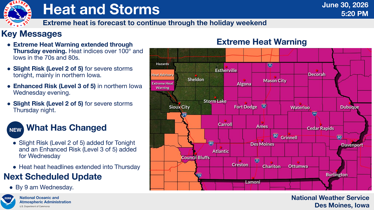
Des Moines, Iowa — June 30, 2026 — North Iowa residents should brace for a dangerous combination of extreme heat and multiple rounds of severe weather as the National Weather Service in Des Moines extended its Extreme Heat Warning through Thursday evening and outlined three separate severe storm threats stacking up ahead of the Fourth of July holiday weekend.
What’s New in This Forecast
Forecasters highlighted two key updates to the outlook:
- A Slight Risk (Level 2 of 5) for severe storms was added for tonight, along with an Enhanced Risk (Level 3 of 5) for Wednesday in northern Iowa.
- The Extreme Heat Warning headlines were extended into Thursday, meaning the dangerous heat will last longer than previously forecast.
The National Weather Service plans to issue its next scheduled update by 9 a.m. Wednesday.
Extreme Heat Warning: What North Iowa Can Expect
The Extreme Heat Warning blankets nearly all of central and northern Iowa, including Mason City, Algona, Fort Dodge, Waterloo, and Des Moines, with a Heat Advisory in effect for far western counties near Sheldon and Storm Lake.
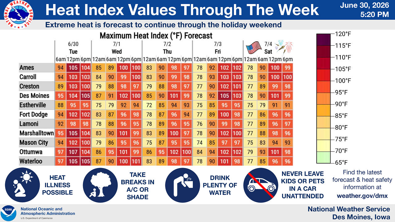
Forecast heat index values show just how punishing the stretch will be:
- Mason City: highs near 102° Wednesday, 95° Thursday, and 97° Friday
- Fort Dodge: highs near 102° Wednesday and 96° Thursday
- Waterloo: highs near 100–101° Wednesday and Thursday
- Des Moines: peaking near 105° on Thursday afternoon
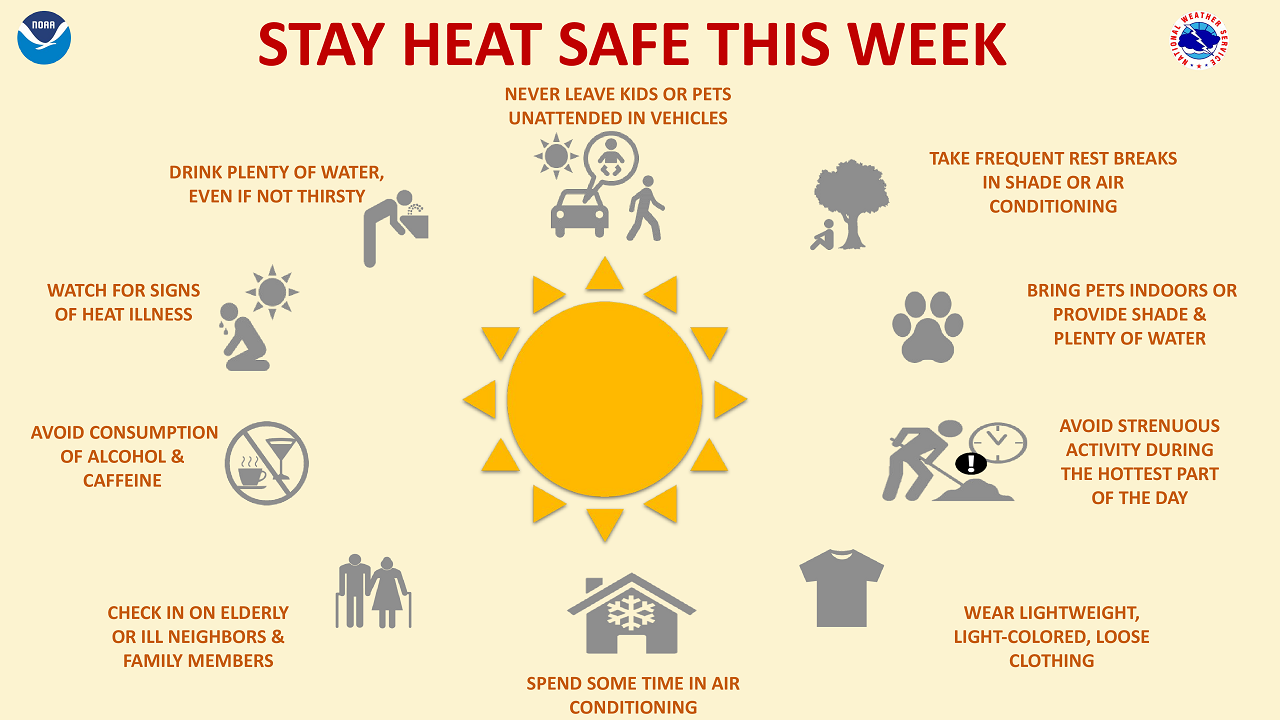
The National Weather Service is urging residents to drink plenty of water even when not thirsty, take frequent breaks in air conditioning or shade, avoid alcohol and caffeine, and never leave children or pets unattended in vehicles. Officials also recommend checking on elderly neighbors and family members and avoiding strenuous outdoor activity during the hottest part of the day.
Three Rounds of Severe Storms Possible This Week
Layered on top of the heat, North Iowa faces three distinct chances for severe thunderstorms over the next several days.
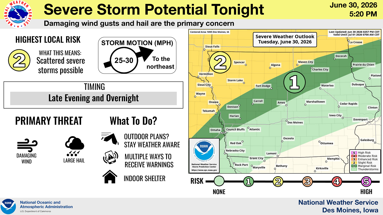
Tonight (Tuesday into Wednesday morning)
A Slight Risk (Level 2 of 5) covers much of northern Iowa, with scattered severe storms possible mainly late tonight into the overnight hours. Damaging wind gusts and large hail are the primary concerns, with storms expected to move northeast at 25–30 mph.
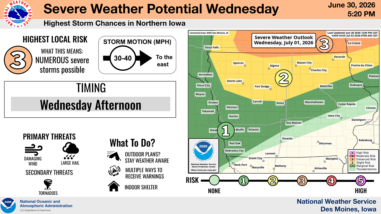
Wednesday Afternoon
The most significant severe weather threat of the week arrives Wednesday afternoon, when an Enhanced Risk (Level 3 of 5) — the highest risk level in this forecast cycle — targets northern Iowa. The National Weather Service says numerous severe storms are possible, with damaging wind and large hail as primary threats and tornadoes listed as a secondary threat. Storms are expected to race east at 30–40 mph.
Thursday Night
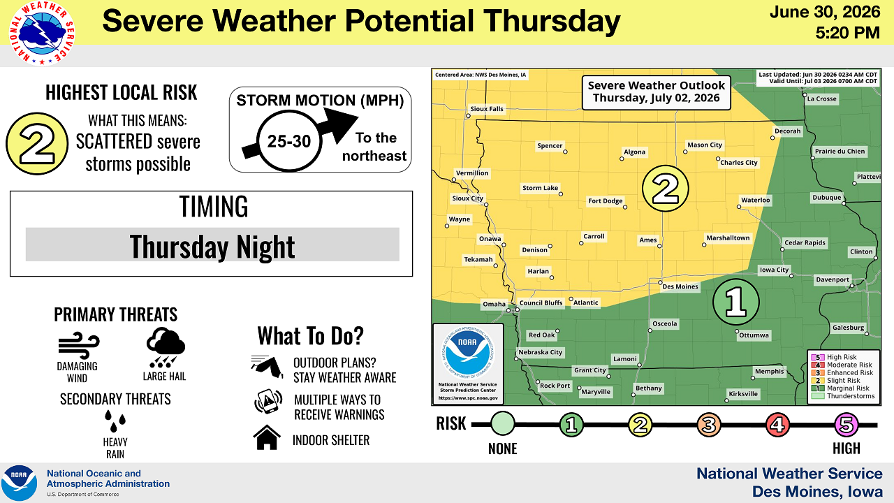
A third round brings a Slight Risk (Level 2 of 5) for scattered severe storms Thursday night, again with damaging wind and large hail as primary threats and heavy rain as a secondary concern. Storms will move northeast at 25–30 mph.
The National Weather Service is encouraging anyone with outdoor plans this week to stay weather aware, have multiple ways to receive warnings, and know where to find indoor shelter if storms approach.
Holiday Weekend Outlook
While Friday and Saturday forecasts show heat index values easing slightly into the upper 90s to around 100°, extreme heat is expected to continue into the July 4th holiday weekend across much of North Iowa.
Stay Connected with KCHA News
Add KCHA News as a preferred source on Google to see more local news, weather, and sports in your feed.
Follow us on Facebook for breaking news, severe weather alerts, sports, and more.
